
Drone goes the distance on hospital project
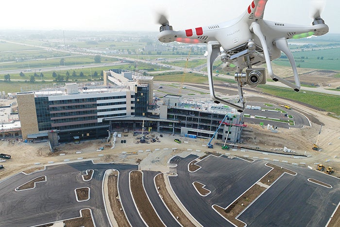
Aerial shots taken by drones help the construction team to plan site logistics.
Photo Courtesy of Uplift Data partners
The new 600,000-square-foot Mercyhealth Hospital and Trauma Center–Riverside project sits on a 65-acre site in Rockford, Ill. Surveying work to help manage various components of the project — safety, logistics, inspection, etc. — would typically take two surveyors two days to complete. Tom Simon of Mortenson Construction is general superintendent on the project. He says thanks to drone technology, that work can wrap up in 30 minutes.
“We are just starting to scratch the surface on this technology,” Simon says. “It’s been refined over the last few years to make it into not just a marketing tool, but a tool that can dial in and be focused on site logistics, schedule management and many more elements.”
Mortenson is working with Uplift Data Partners, a drone service provider for the construction industry. The drones have the ability to capture 2-D data, such as photos and videos, and 3-D models. The data integrate with the project’s 3-D modeling programs and software. The project team can then take that information and apply it to its decision-making. For instance, at any one time, the site can have 10 pieces of equipment each moving 1,000-1,500 cubic yards of dirt per day. Aerial photos taken by the drones — which are within one inch of accuracy — can help to plan how that equipment should maneuver.
Related Articles
The facilities manager’s role in reducing healthcare-associated infections
From multidisciplinary communication to establishing safety procedures for construction, remediation and maintenance, facilities teams play a critical hand in reducing patient infections.

AdventHealth expands in Tampa Bay with new patient tower
Expected to open in 2029, the new six-story patient tower at AdventHealth Carrollwood will expand inpatient and surgical services for the rapidly growing area.
2026 Vista Award winner Morristown Medical Center
The winning infrastructure project required an untangling of existing systems to provide durable electrical power.